Boundary Surveys
Subdivision Platting
Subdivision Platting

A boundary survey is a way to formally define the boundaries of a property. It focuses largely on defining the corners of a parcel of land. Owners generally commission boundary surveys before buying, dividing, improving, or building on the land.
Subdivision Platting
Subdivision Platting
Subdivision Platting

Platting is the process by which the owner develops the property in accordance with the local code. Once the process is complete, the parcel is approved for the connection of available utility services to include 911 emergency access.
ALTA Surveys
Subdivision Platting
Title Surveys
ALTA, the American Land Title Association, specifies data to be shown on surveys. The guidelines are determined by ALTA and ACSM, the American Congress on Surveying and Mapping. ALTA land surveys are made for Lenders or Title Companies and contains the data needed to issue a title or mortgage insurance.
Title Surveys
Title Surveys

A land title survey is prepared by a Texas Registered Professional Land Surveyor, identifying record property lines, easements, rights-of-way, and adjacent properties for use by the title company.
Topographic Surveys
Land survey services are asked to produce topographic surveys for construction and architectural projects. The survey is primarily concerned with noting the natural features of the land itself. These may include hills, ravines, streams, and trees.
Construction Staking
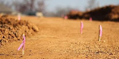
Construction Staking, also known as a Site Layout Survey, is the process of interpreting construction plans and marking the location of proposed new structures such as roads or buildings. Construction staking is performed to ensure a project is built according to engineering design plans.